Australian Geoscience Council Inc.
Inventory of Geotrails in Australia.
In April 2021, Professor David Cohen, the President of the Australian Geoscience Council (AGC), announced the release of the Council’s National Geotourism Strategy (NGS). A year later, the Australian Government’s THRIVE 2030 Visitor Economy Strategy has proposed an action for industry to ‘grow and develop high-quality products and experiences around unique Australian locations and themes, including approaches which integrate sustainable nature tourism with economic opportunities for Traditional Owners, and capitalising on emerging tourism trends such as geotourism.’
One of the seven strategic goals of the NGS is to establish a framework for creating high quality, sustainable geotrails, a key goal that meets this national strategic need. Through the NGS and in collaboration with the Geotourism Standing Committee of the Geological Society of Australia, the AGC has now listed over 80 geotrails in a new schedule, ‘Inventory of Geotrails in Australia.’
Many of the listed geotrails are already established and all have links to web pages for further information. The listing is not exhaustive as it ‘represents work in progress’. In addition, the NGS Geotrail Working Group is currently developing how this schedule can best be linked to an interactive and searchable map of geotrails (both localised and regional) across Australia.
The National Rock Garden (NRG) will soon be relocated into the National Arboretum and hence, with inclusion of the surrounding landscape, could become a Geotrail. The NRG celebrates Australia’s rich geological heritage in a parkland setting within the national capital, with a permanent display showcasing the diversity of the rocks and minerals that contribute so significantly to the nation’s landscapes, heritage and prosperity. Ongoing enhancement of the NRG with the recent acquisition of two rocks (Mawson Charnockite) from Antarctica. A large boulder of Middledale Gabbroic Diorite (NSW), a proven source of zircon crystals will soon be on display. NT’s Mount Goyder Syenite is part of NT’s ‘ignite project’.
A 4 km walk developed from Shelly Beach to Rocky Beach that includes a story on how the Earth’s crust was formed over the past 460 million years. A collaboration between the University of Newcastle, Department of Regional NSW’s Geological Survey (GSNSW) and the National Parks and Wildlife Service (NPWS).
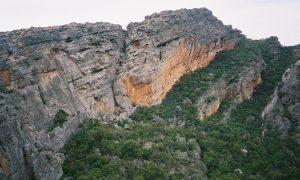
Geotrail along Bathers Way, Newcastle Coastal region. It blends science with geological and human history, the geotrail explores the prominent rock platforms and cliffs of the coastline from Nobbys Headland to Merewether headland, revealing how the amazing geology has influenced natural features and cultural heritage along the coastline. The project was a collaboration between the Department of Regional NSW and the University of Newcastle.
A series of geotrail tours at the Warrumbungle National Park which tells the story of the huge extinct volcano which forms the landscape at the park. The geotrails follow three of the main bushwalking trails, plus an accessible walking tour in the Central Valley and a road-based tour which runs east-west across the park. The project was a collaboration between Department of Regional NSW (GSNSW), NPWS, Warrumbungle Shire Council, Warrumbungle Environmental Educational Centre and local Aboriginal representatives.
An extensive road-based geotrail (600-700km) follows the Darling River north from Wentworth, through Pooncarie and Menindee to Wilcannia, then extends up through White Cliffs to Peery Lake. The Mungo, Kinchega and Paroo-Darling National Parks are included in the geotrail by utilising existing sites, paths or road routes. The geotrail will provide insights into the geomorphology and sedimentary geology of the river and lake or dune influenced landscapes, ancient oceans and megafauna, opal mining, and artesian basin geology. Relevant aspects of aboriginal and european history will also be included. The project is a collaboration between Department of Regional NSW (GSNSW), NPWS, shire councils and community groups. Aboriginal representatives are also engaged with the project.
Website – in progress.
A geotrail for the Mutawintji National Park is in development, integrating existing walking trails. Recent geological mapping results, story content on fossils in the park and ancient environments, and Aboriginal cultural heritage are the main features. A close collaboration between Department of Regional NSW (GSNSW), NPWS and the Mutawintji Board of Management (Aboriginal representatives).
Website – nearing completion
Smart Phone Application which hosts the Department of Regional NSW (GSNSW) geotrail free app tours
Geotrails are being developed in partnership with the NSW National Parks and Wildlife Service and the three local government agencies (Ku-ring-gai, Hornsby and Northern Beaches), and are now at an advanced stage in preparing geotrail guide notes (text and pictures) for the localities of West Head, Brown’s Field, Long Reef and Thornleigh diatreme. Advanced planning is underway with Northern Beaches, Ku-ring-gai and Hornsby Councils and with National Parks.
The Glen Innes Severn Council in far northern NSW in partnership with the GS NSW plan to develop a number of geotrails:
- World Heritage Way – drive from Grafton-Glen Innes-Narrabri (or Warrumbungles)
- World Heritage Walk – within Gibraltar Range and Washpool NP
- State Tourist Drive (Route 11) Miners Way – Fossickers Way
New England Rail Trail
A regional, collaborative, multi-land use strategy which will provide for development within rehabilitated mined areas with uses such as native flora and fauna habitat conservation, ‘soft adventure’ recreation, coal mining heritage (museum type) sites, geosites and geotrails, sites set aside for renewable energy generation, innovative, food production and ‘value add’ manufacturing, and engagement with aboriginal people. Under the Upper Hunter Economic Diversification Plan, as the open cut mining operations start to move away from an active to a decommissioned stage, there will be the process of mine site rehabilitation for the estimated 23 final voids in the Muswellbrook-Singleton area.
The Rail Trail from Casino to Murwillumbah will provide a world class product expanding the product offering in the region. It covers a rich diverse blend of landscapes, destinations and visitor experiences.
The NRRT section 1 is now fully funded with matching commitments of $6.5 million by the NSW and Australian Governments, along with $900,000 funding from the Lismore Government.
Broken Hill geotourism brochure is available which describes two self-guided geological tours: a 6 km walk around the city, and a drive around the region.
A conceptual east-west geotrail to include the Age of Fishes Museum in Canowindra, and the Australian Fossil and Mineral Museum in Bathurst with other geological sites. For instance, the Canowindra site features armoured fishes, fishes with lungs and some huge predators with jaws like crocodiles, and gives a unique glimpse into life during the Devonian Period.
The Australian Fossil and Mineral Museum features some of the finest and rarest specimens of mineral crystals and fossils from around the world. The centrepiece of the exhibition is a Tyrannosaurus rex skeleton.
A Guided Fossil Walk along Ulladulla Harbour along the rock platforms. On the north side is a 500 million year Geological Time Walk. Fossil House is in CBD Ulladulla.
This walk received Best Tourist Attraction on NSW South Coast Award in 2016.
This trail covers 116 sites described and accessible between the Nepean River and the Bathurst Flag Staff Commemorative Site. Includes 80+ pages and 8 maps.
Opportunity to develop a ‘cluster’ of related geotourism projects across the Blue Mountains National Landscape:
- Jamieson Valley/Katoomba proposals of the Blue Mountains HWI
- Destination Pagoda project in the Lithgow area
- Cox’s Road ‘Geotrail’
- Great West Walk
Localised walking trails managed by the NPWS including the Three Sisters
The GSA and the AGC recently collaborated to make parallel submissions to the NT Parks 30 Year Masterplan. The submissions emphasised the opportunity of building geotrails within and between NT parks as well as recommending that park management devote more attention of interpreting and celebrating the outstanding geoheritage in these park areas. Integrating geological and geomorphological information with the cultural and environmental aspects will lead to a holistic experience for visitors and Territorians alike. Traditional owners and the Northern Territory Government realise the benefits of future joint management of national parks such as Nitmiluk, Tjoritja and Watarrka.
The Darwin City Geotrail (DCG) was released by Marmel Enterprises in August 2020 with the 6.5 km route covering over 70 sites of interest. It is a multi-interest virtual geotrail and features the 1.8 Billion year aged Burrell Creek Formation from the Pine Creek Orogen, and the Darwin Formation from the Jurassic/Cenozoic Money Shoal basin, a ‘mere’ 100 million years old. The DCG features other sites of historic, scenic and cultural interest for a diverse and integrated tour. It’s designed to provide an overview of Darwin City and its evolution for those with limited time to spend in the CBD but wanting to learn and experience more about Darwin and the surrounding region.
Enhancements to the DCG are planned to incorporate new sites, more information, and more varied content.
The Pine Creek Miners Park is located on the railway historical reserve in Pine Creek with the site managed as part of the National Trust Estate. The site was originally set up in 1988 by AusIMM Darwin branch and other volunteers with interests in the Pine Creek region. It comprises a collection of machinery and items associated with mining in the region, and includes winches, pumps, boilers and the like. There are interpretive displays and information on each of the items as well as on mining in the region. AusIMM are currently managing the repair of minor damage, upgrading signage and improve overall aesthetics of the site.
AusIMM and Marmel Enterprises have partnered and secured funding and in-kind recourses to progress the Pine Creek geotrail concept. Discussions with several prominent stakeholders to progress the concept have occurred, and it is planned to launch the geotrail later in 2022. A walking geotrail, similar to the Darwin City Geotrail has been proposed to the stakeholders involved.
The second stage of the Pine Creek Geotrail extends the vision of a regional experience based around the historic mining town of Pine Creek.
The strategic pursuit of an integrated set of Geotrails across the Top End. Planning has commenced through Marmel Enterprises resources, but it is still in the conceptual stage and it is recognised additional partnerships, funding and resources will be required to realise the TEGN.
It is envisaged that the Darwin City Geotrail and Pine Creek Geotrail will form part of the Top End Geotrail Network.
The 1135 kilometre Red Centre Way loop covering 6-days from Alice Springs passes through Tjoritja/West MacDonnell Ranges, Watarrka/Kings Canyon, and Uluru-Kata Tjuta National Parks, and is a popular self-drive and/or guided tour. It is heavily promoted by Tourism NT and many operators use the track. There would be scope to increase the ‘geo’ content of the drive. However, some aspects are fairly well covered, although locally outdated, with existing promotional and informative materials and signage along the way.
Situated west of Alice Springs, the Larapinta Trail extends over 223 km along the backbone of the West MacDonnell Ranges and is one of the most spectacular hiking experiences in the world.
A geological guide providing information about minerals, rocks, geological processes and landscape, as well as some historic and cultural aspects will be published as a small book (supported by NT Geological Survey and GSA). It will be suitable for day walkers and multi-day hikers alike.
Standley Chasm/Angkerle Atwatye is situated in the West MacDonnell Ranges ~40 km west of Alice Springs. It is privately owned and operated by the Western Arrernte People. A 2.4 km round-trip walking trail provides easy access to an area that has deep spiritual significance to the local custodians. A narrow gorge rich in endemic plant and wildlife culminates in a geologically spectacular, ~3 m wide and 80 m high chasm.
Through funding by the GSA, members of the AGC National Geotourism Strategy working groups and the GSA are working with the local traditional owners to produce a tour brochure which brings together all of the key natural and cultural heritage elements. The brochure content could be made available through a smart phone App.
The Larapinta Trail and Standley Chasm/Angkerle Atwatye projects will provide case studies and material that can be further developed into a geological/ landscape/historical/cultural guide covering the self-guided drive through Tjoritja/West MacDonnell National Park and its individual attractions (e.g. Ellery Big Hole and Ormiston Gorge).
This project is still in the planning stages.
Ferny Grove Rail Trail provides a cycle connection from the Samford Valley to Ferny Grove Rail Station. The route crosses from Devonian/Carboniferous deep marine (accretionary complex) rocks onto the Triassic Enoggera Granite stock (biotite granite/granodiorite), and shows physiographic differences between country rock, contact aureole & granitoid stock.
GSA-QLD has sponsored a project to log the geology along a continuous 305 km stretch of recreational trails between Wulkuraka and Kilkivan in SE Queensland. The three segments are the 161 km Brisbane Valley Rail Trail (BVRT), the 88 km Kilkivan-Kingaroy Rail Trail (KKRT) and the 55 km Yarraman-Kingaroy Link Trail (YKLT). There is a proposal to extend KKRT eastwards towards Main North Line potentially to Theebine.
Note: Brisbane Valley Rail Trail by Bill D’Arcy and George Winter; Kilkivan Rail Trail by Bill D’Arcy and George Winter.
Summary *.pdf files for BVRT & KKRT are available from the GSA QLD website, the YKLT leaflet *.pdf file is in preparation.
Visit Website for pdf files
A 10 km established pedestrian/cyclist asphalt path along the route of the Kilcoy Branch Line at the northern outskirts of the Brisbane’s suburban sprawl. Bits and pieces of the branch line further out lie in various reserves controlled by State Government and are accessible to the public, but much was sold off in the 1960’s and is under private ownership. The Branch Line was ~50 km; There is potential for ~15-20 km as discontinuous geotrail fragments (including the 10 km Rail Trail).
Studies are planned for an extension of the Mary Valley Rail Trail (MVRT) northwards along the re-commissioned Mary Valley Branch line. The Gympie Regional Council is supportive.
Southern 5 km (established MVRT) has been geologically logged, with a further 16.8 km as a proposed extension to MVRT. The northern 23.3 km is heritage railway (Mary Valley Rattler). A geotail pamphlet for the 5 km MVRT is in preparation.
Recent State & Commonwealth funding was granted to Logan City Council for Feasibility & Business Case Studies of portions of this former 43 km rail branch line. This is likely to become a rail trail (at least in part) with potential to become a Geotrail.
Esk recreational trail is being developed by Somerset Regional Council. The main features of the landscape are the Brisbane Valley itself, ranges to the east and west, and the Mount Glen Rock, Mount Esk and Burrundun Mountain complex on the eastern fringes of the town. This is a mass of rhyolite which rises over 400 metres. Esk Creek is a superimposed/antecedent stream in a gorge up to 250 m deep, cutting through the rhylolite mountain.
Covering over 1,100 km over 8 programmed days, this east-west orientated trail begins from the World Heritage-listed Great Barrier Reef and pristine beaches of Townsville, to the rugged rocky outcrops and red sand of north-west Queensland. The Overlander’s Way will take you through towns rich with history, dinosaur discoveries and some of the world’s quirkiest events; all without having to leave the bitumen.
Dramatic gorges, lava tubes and brilliant gemstones are the highlights of the Savannah Way through the Etheridge Shire. It covers the McBride Volcanic Province where eruptions millions of years ago formed a spectacular landscape and left behind a rich mineral heritage. It covers two self-drive loops that includes Mt Surprise, Georgetown, Forsayth and Einasleigh.
The world-famous outback triangle that links the historic towns of Hughenden, Richmond and Winton are home to some of the world’s best preserved dinosaur fossils—all scattered across Outback Queensland for hundreds of millions of years. This includes Australian Age of Dinosaurs, Winton and Eromanga Natural History Museum.
Visit Queensland Dinosaur Trail Website
Over 600 million years old, the Flinders Ranges is one of Australia’s magnificent landscapes. Particularly extraordinary are the fossils and geology of the Flinders Ranges, which display the history of our planet and the evolution of life on Earth. The Flinders Ranges contain one of the most intact and rich Ediacara fossil sites in the world. The fossils provide the earliest known evidence of multicellular animal life — over 540 million years ago. So important are these fossils that the Ediacara period has been named after them. The GSA (SA) Division’s Field Guide Subcommittee have published a 20 km Brachina Geotrail self-guided Field Guide pamphlet covering 20 geosites that passes through 130 million years of Earth’s history, transecting the Adelaide Geosyncline in the northern Flinders Ranges.
The South Australia Divisional ‘3G’ Subcommittee (Geoheritage, Geo-Guides and Geotourism) is looking at better promoting the series of existing GSA Field Guides externally to the community – especially to LGA’s for geotrail opportunities as they seek initiatives to enhance regional tourism. The Field Guides include geotrails and potential geotrails across the State – eg Central Eyre Peninsula granites (archaean outcrops and granite inselbergs of the Kimba-Wudinna region – flared slopes, gnamma pits and extensive tafonis), Port Victoria (a short foreshore walk along this seaside town covering Proterozoic exposures of the Gawler Craton’s southern reaches – currently being revised by the authors), Adelaide North Terrace (colonial stonework including Parliament House, SA Museum, Adelaide University and former Institute of Mines), Victor Harbor (extensive metamorphosed Cambrian sediments uplifted to form the ancestral Mount Lofty Ranges, glaciation, erratics, striations and Pleistocene calcareous dunes), Lower Murray (showing tertiary limestone gorge carved by the Murray River through progressively uplifting carbonate sea floor, wetlands, granite intrusions, marine fossils and middens), Kangaroo Island (18 geoheritage sites ranging from Proterozoic to Quaternary), Robe Coastline (Quaternary aeolianite cliffs of the Bridgewater Limestones, bays, stranded Quaternary dune ridges with wetlands reflecting Ice age sea levels and regional uplift), the Mount Gambier Volcanic Complex (geotrail over several kms of walking and driving trails around four major explosive centres, exposing karst aquifer in the Blue and Valley Lakes), etc. See the brochure for the full list.
GSA Field Guide highlighting Bridgewater aeolianite coast lines, bays, inlets, sea caves and karst blowholes of western Eyre Peninsula and Murphy’s Haystacks – prominent and elaborately-weathered granite pillars protruding from wide ancient fluvial plains.
GSA in conjunction with Whyalla Council – a short triangular walk with views across the head of Spencers Gulf where the Adelaide Rift Complex (Flinders Ranges) coalesces with the Cultana Plateau of the Gawler Craton, fringed by the Fitzgerald Bay Stranded Shingle Ridge State Heritage site.
The GSA in conjunction with Goyder Council is preparing a 200 km geotrail looping around the Burra Copper mine region through the eastern Adelaide Rift Complex overlooking the great divergence to the Curnamona Province to the northeast and the Morgan Fault zone of the Murray Basin limestone plains to the east. It also intersects in many places with the famous ‘Goyder Line’ – the 10” rainfall limit delineated by SA’s Surveyor General Goyder in 1865, beyond which he designated agricultural cropping as too risky. Thousands of early settler farmers disregarded this advice to their ruin.
Geotrail in preparation in 2022 – planned for launch at September Mining History conference in Burra.
GSA Field Guide was launched in 2020 exploring the Sturtian Tillite of the Cryogenian ‘Snowball Earth’ glaciation in the hills and gorge behind Flinders University in southern Adelaide.
A developing Urban Park showing a steep creek system with early mining relics cutting a transect through the western edge of the uplifted Adelaide Rift Complex.
GSA Field Guide and Field Geology Club Booklet showcasing outstanding Neoproterozoic folding, Permian glaciation striations, wave-cut platforms and fluvial sediments.
GSA Field Guide covering the Willunga Embayment with extensive Tertiary limestones and sandstone beds with extensive marine fossils uplifted from Gulf St Vincent.
GSA Field Guide describing steeply dipping metamorphosed and faulted proterozoic sediments of the Adelaide Rift Complex inland of the prominent Willunga Fault line.
Deep Creek National Park trail upgrade – coastal cliffline walk transecting the Adelaide Rift Complex, tracing the drowned river system that separated Kangaroo Island from mainland.
In planning stages 2022-23
GSA Field Guide covers coastal Quaternary dunes and back barrier lagoon series, shallow water dolomite and magnesite in Holocene carbonate lakes, first oil drilling geosite at Salt Creek – historical rig construction and panels.
A planned geotrail to cover karst features of the Gambier karst sheet and associated Tartwaup and Nelson Faults, including water-filled cenotes and coastal karst springs. Currently in discussion with LGAs.
Spanning the ‘Newer Volcanics’ field – Australia’s most extensive volcanic province, a 400 km x 150 km coastal zone of South West Victoria & South East South Australia. This was the former UNESCO Kanawinka Volcanic Geopark from 2008-2012, in the hinterland from the Great Ocean Road. Since 2012, now re-named as the Kanawinka Geotrail, it’s an area of ~400 volcanic sites and extensive lava flows and in SA, sweeping limestone plains studded with remarkable sinkholes and caves. Seven local Council/Shires have produced a full-colour glossy A2 fold out brochure/regional map detailing 60 geosites with an easy to read location map and individual geological site description which have been distributed through 20 Visitor Centres.
A 2020 paper has been released detailing recent studies of the cliffs with dates of 5 Ma – far older than previously thought. A previous World Heritage nomination bid in the early 1990’s foundered due to SA-WA Governments’ differences of approach and perceived management difficulties if designated.
Potential for 2023-24
A recognised Australian National Landscape area – significantly impacted through the Bushfires in 2019-2020. Extensive rehabilitation of areas and construction of new tourism related infrastructure currently progressing. Comprehensive karst exploration and logging of features exposed by bushfires in the Kelly Hill Caves region. Tourism is now recovering. Potential for an Island-length Geotrail using existing map resources and a possible model for a ‘Geo-Region’.
Alliance formed in 2019 to combine the natural and build heritage of SA with a focus on Strategic planning and Project Development, and a policy of increasing nominations of natural heritage sites (read: Geosites).
Geotrail covering the landscapes and geology of Western Tasmania ‘Living Earth‘ Geotrail, detailing natural and historic mining features connecting Zeehan, Roseberry and Queenstown. Each site has a roadside sign with QR Code web-link to Living Earth website.
A 60 km self-guided roadside geological trail created in 2014 launched to highlight 13 of the North West Coast’s unique geological features between Devonport’s Mersey Bluff and Wynyard’s Table Cape.
The Furneaux GeoTrail – Flinders Island consists of 26 geosites which provide an opportunity to learn about the geology and important geological events that have shaped the current landscape.
A series of brochures outlining the geology of important sites on King Island was put together by Clive Calver in 2017.
This walk follows the footsteps of Charles Darwin when he visited Hobart on the HMS Beagle in 1836. A series of interpretive panels describe the local geology.
A feasibility study documenting the potential of four Geotrails in NW Tasmania and King Island. Some of the documented Geosites have been incorporated into the West Coast, Created from Chaos and King Island Geotrails.
World Heritage listing of Australia’s Central Victorian Goldfields aims to share the extraordinary story of the Central Victorian Goldfields with people from across the globe and create social, cultural and economic opportunities for every community and person across the region. The most extensive, coherent and best-surviving goldrush landscape, anywhere.
The rich history of the gold rush that shaped the towns and countryside of Beechworth, Chiltern, Rutherglen and Yackandandah can be explored on a fascinating self-guided tour of the Indigo Gold Trail.
This trail connects to the Indigo Gold Trail (via a branch from Everton Station to Beechworth).
Extrapolating over the coastal borders of South West Victoria & South East South Australia is the recently released Kanawinka Geotrail – Australia’s most extensive volcanic province. It’s an area of sweeping limestone plains studded with remarkable sinkholes and caves, spectacular volcanic formed mountains and extensive lava flows. Seven local Council/Shires and have produced a small fold out into a DL size brochure detailing 57 geosites with an easy to read location map and individual geological site description. As a proposed connection to the regional Kanawinka Geotrail, it has been proposed that the former Great Ocean Road National Landscape be reconfigured as another major regional geotrail.
The Murchison GeoRegion project covering 40,000 sq km is a collaborative project with representatives from the seven local government areas of Cue, Meekatharra, Mount Magnet, Murchison, Sandstone, Wiluna and Yalgoo, and additional support from external agencies and stakeholders which has established a self-drive geotrail to visit 21 sites of national and international, natural and cultural significance. Website has a free app along with an A5 size, 42-page Murchison GeoRegion Trail Guidebook ‘Ancient Lands – Brilliant Skies’.
GSWA has just released a new geotrail A5 size, 47-page booklet. It describes the geology along the former mainline up the Darling Scarp about 22 km east of Perth where the railway cuttings expose the rocks. It gives interpretive geological descriptions of the cuttings, explains several geological features, processes and principles such as the rock types, their genesis and how they relate, jointing and faulting as produced by tectonics, and includes reference to a number of local and regional geological features.
The Kalbarri Skywalk is perched right on the cliff-top. Two 100-metre-high lookouts project 25 and 17 metres beyond the rim of the Murchison Gorge and give spectacular views over the 400 million year old sandstone that forms the gorge.
‘Stepping stones’ is a pamphlet produced by the Geological Survey of Western Australia (GSWA), which accompanies two self-guided geology walking trails in Perth. Trail 1 of Stepping stones leads you through the city from East Perth to the foot of Kings Park to find a floating granite sphere, heritage gardens and other geological features. Trail 1 can also be followed using an app on your smart device.
Trail 2 stroll along St Georges Terrace in the Perth CBD. You can see façades, pavements, stairways and columns made from many different polished and honed rocks.
Star Swamp is a 100-hectare native bushland approximately 15 km north-west of Perth. It is planned to link soil profiles with limestone outcrops.
The Fimiston Open Pit, colloquially known as the Super Pit, was Australia’s largest open cut gold mine until 2016 when it was surpassed by the Newmont Boddington gold mine also in Western Australia. The Super Pit is located off the Goldfields Highway on the south-east edge of Kalgoorlie. There are several lookouts and Open Pit Mine Tour.
Discovery Trails to early Earth of the Pilbara region includes six geotrails in a single book with Google Earth links to the individual features. The six drive trails radiate from the township of Marble Bar and visit amazing natural formations; you can read about their geological history and how they were formed. It uses GPS-referenced stops for easy location, a double-page spread for each stop describing what you see and how the feature formed, and illustrations, annotated photos and diagrams.
A booklet describes a journey along the 37 km-long arcuate scarp formed during the earthquake of 14th October 1968 along the underlying geological structure — the Meckering Fault. It includes pictures of the surface trace of the fault comprising multiple, mostly acuate, segments from a few hundred metres up to about 10 km long. Sections of the fault show different features such as thrust and normal faulting, strike-slip (mainly dextral, or right-lateral) displacements, and combinations of these. There are also extensional fissures, surface bulging, and en echelon (oblique ladder-like) tension fractures. Offset features such as roads and fence lines indicate that the ground on the eastern side was thrust over ground on the west, and the western side was shunted northwards relative to the eastern side.
Starting from opposite the Greenbushes Discovery Centre, the 3 km Mining Heritage Walk loops around the edge of town. Featuring an old mining tunnel and hand-dug shafts and trenches, the trail explores the rich history of tin mining in the Greenbushes area starting in 1886. The Mine Lookout overlooks the open pit.
A comprehensive list of trails south and southeast of Perth from Mt Augustus, to the snow white beached and turquoise waters of Esperance.
The Peel Region WA Aspiring Geopark centred on Mandurah, have identified 15 geosites to form a geotrail(s) and are designed on how different rock types affect the different flavours of wine in the region. The Mayor of Mandurah is very supportive.
Just 40 km south of Mandurah are the Lake Clifton thrombolites which are thought to be over 2,000 million years old.
In progress
Established ‘Geotrail’ via DMIRS Rottnest Island – A geology guide. On-line information, Smartphone App
ECU Masters thesis “Stakeholder perceptions of establishing a Geopark on Rottnest Island”.
In progress
Calls by geoheritage specialists that this area may be suitable for an estuarine geopark. Independently, UTAS Masters student has also suggested the area may be suitable for georegional consideration.
In progress
This georegion is being developed centred around Kellerberrin using geology and aboriginal landscapes.
PhD thesis “Stakeholder perceptions of establishing a Geopark in the Wheatbelt”.
Currently discussions between Alan Briggs and local councils are in progress.
Workshops planned in outlining Geotourism concepts and georegional development options
Council is very supportive of a geosite/geotrail and there are ideas to have it as the first ‘paperless’ Geopark
VLF (Very Low Frequency) radio aerial system as a source of radio waves of use in geophysical data accession. It is one of the most powerful transmitters in its class in the world. The signal from which is used near globally for shallow EM surveying while simultaneously being a major source of noise for deep EM surveys.
Planned
Geological History over billions of years (3-4 Bill) in development, fauna and flora development, evolving with time and to places; aboriginal culture – 40,000 to 60,000 years of living culture; early European exploration, pastoral and land use; Contemporary land use – cropping, grazing, sandalwood, mining, tourism
Potential.